2. 中国科学院水利部水土保持研究所土壤侵蚀与旱地农业国家重点实验室, 陕西杨凌 712100;
3. 西北农林科技大学水利与建筑工程学院, 陕西杨凌 712100;
4. 河北农业大学河北省山区研究所, 河北保定 071001
土壤水文是水文循环和水量平衡的关键过程[1-2]。黄土高原退耕还林还草工程实施后,地表覆被条件发生了重要变化[3],进而通过改变土壤结构和物理特性,如土壤入渗特性和土壤持水能力,对地表的产汇流过程以及水分运动过程产生了重大影响[4-5]。植被的自然恢复能显著改善土壤结构状况,增加土壤的入渗性能,提高土壤蓄水及持水能力[6]。黄土高原下垫面环境条件的改变可能对流域水文过程、水文通量、水量平衡以及生态系统产生十分重要的影响[7]。因此,研究黄土高原下垫面环境条件变化下剖面土壤水分的运动过程,对于揭示流域产汇流过程以及影响机制具有重要的理论意义和科学价值。
黄土高原坡面的产汇流机制是否因下垫面环境条件改变而发生着重要变化,至今尚难定论[7-9]。同一位置、多深度、稳定、连续的土壤水分动态监测和定量化研究,可以揭示土壤水文参量在不同尺度上的真实状况,更准确地描述和模拟水文过程,有助于回答流域下垫面变化是否引起黄土高原坡面产汇流机制的变化。80年代以来,降雨-入渗-产流过程及机理的研究成为水文学领域的热点,在流域尺度上对降雨强度、土地利用、植被类型与恢复年限、地形坡度、土壤特性、水土保持措施等方面开展了降雨产流规律和影响因素的大量研究[6]。近年来,在全球气候变化背景下,极端干旱和极端降雨频发,钟科元等[10]研究发现极端降雨对松花江流域径流输沙量的影响异常强烈。李慧娟等[11]研究发现高强度、短历时的极端降雨事件造成了梯田的严重破坏和滑坡等重力灾害的发生。极端降水量和极端降水强度呈增加态势[12],坡面土壤入渗-产流特征与机制得到学者们普遍关注。本文通过分析2017年黄土丘陵沟壑区发生在陕北绥德的“7·26”特大暴雨事件和坡面草地土壤剖面水分的动态响应关系,阐明了特大暴雨事件下土壤蓄水能力和土壤水分的入渗过程,揭示了极端暴雨条件下的土壤水文参量特征与变化规律,对于研究流域的产汇流机制具有十分重要的意义。
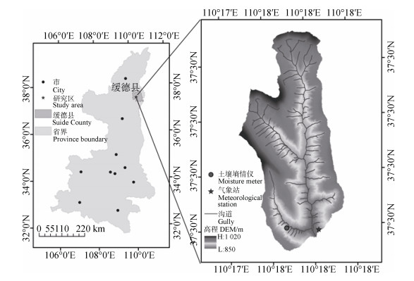
1 材料与方法 1.1 研究区概况研究区位于陕西省榆林市绥德县裴家峁村桥沟小流域(37°29′41″N,110°17′56″E),是裴家峁沟的一级支沟,属于黄土高原丘陵沟壑区第一副区(图 1)。流域面积0.45 km2,主沟长1.4 km,沟壑密度5.4 km·km-2。流域内有两条支沟,其中一支沟沟长为870 m,沟道比降为4.97%;二支沟沟长为805 m,沟道比降为1.15%。桥沟流域坡度集中在11°~49°,占整个流域面积的69%。流域多年平均气温10.2 ℃;平均降雨量约486 mm;降水主要集中在雨季6—9月,约为年降水量的70.4%,且多以暴雨形式出现。流域水土流失严重,年平均侵蚀模数为3 423 t·km-2·a-1,以水力侵蚀和重力侵蚀为主[13]。
|
图 1 桥沟流域及土壤墒情仪和气象站分布图 Fig. 1 Location of the Qiaogou watershed, moisture meters and meteorological station |
研究区植被以草本为主,主要有艾蒿(Acroptilon repens(L.)DC.)、狗尾草(Cynosurus L.)、本氏羽茅(Achnatherum sibiricum(Linn.)Keng.)、胡枝子(Bush CloverLespedeza bicolor Turcz.)、百里香(Thymus mongolicus Ronn.)、白草(Pennisetum centrasiaticum Tzvel.)、猪毛蒿(Artemisia scoparia Waldst.et Kit.)、冰草(Agropyron cristatum(L.)Gaertn.)等数十种,多分布于沟谷的荒坡上,人工草地较少。
1.2 降雨量降雨数据时间尺度为小时,来自陕西省绥德县桥沟气象站观测资料,时间为2017年7月25日—2017年7月26日的逐时观测资料。降雨日值数据均由小时数据叠加计算所得。“7·26”极端暴雨事件的降雨特征值如表 1所示。
|
|
表 1 “7·26”极端暴雨特征值 Table 1 Eigenvalues of the"7·26"severe rainstorm |
采用北京东方润泽生态科技股份有限公司生产的土壤墒情仪(TD200),监测深度为0~200 cm,间隔为10 cm,共20层。土壤墒情仪(TD200)利用FD原理[14]建立振荡频率与土壤含水量之间的指数关系,监测土壤水分的相对百分误差为≤3%。土壤的介电常数主要依赖于土壤的含水量。通过FD原理建立土壤的介电常数与土壤含水率之间的对应关系,建立SF(Scaled frequency)参数与土壤容积含水量θv之间的指数关系式
| $ {\theta _v} = a{\rm{S}}{{\rm{F}}^b} $ |
式中,θv为土壤容积含水量,SF为土壤的介电常数,a、b为待定参数。
容积含水率是克服土壤变异性对土壤含水率测量影响的一种有效方法[15]。SF定义为
| $ {\rm{SF = }}\frac{{{F_a} - {F_S}}}{{{F_a} - {F_w}}} $ |
式中,Fa为仪器放置于空气中所测得的频率,Fw为仪器放置在水中所测得的频率,Fs则为仪器安装于土壤中所测得的频率,a、b为待定参数。
土壤蓄水量公式为[16]
| $ {S_i} = {\theta _i}{h_i};\;\;S = \sum {_{i = 1}^n{S_i}} $ |
式中,Si为每层土壤蓄水量,mm;θi为土壤体积含水量,%;hi为分层厚度,10 cm;n为土壤层序号;S为土壤总蓄水量,mm。
1.4 入渗过程模拟采用Horton模型对实测入渗水量随降雨历时的变化进行拟合和显著性检验[17],研究降雨条件下土壤中入渗水量随时间的变化关系。Horton入渗模型:
| $ f = {f_c} + \left( {{f_0} - {f_c}} \right){{\rm{e}}^{ - kt}} $ |
式中,f为t时刻下的下渗速率;fc为稳定入渗速率,f0为初始入渗速率,t为时间,k为系数,反映土壤的下渗性能。
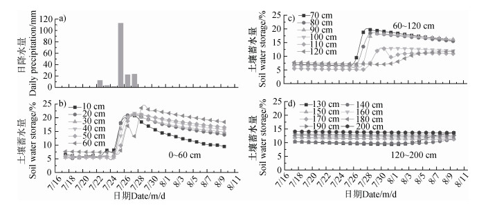
2 结果 2.1 极端暴雨条件下土壤剖面蓄水过程的动态变化“7·26”极端暴雨条件下,桥沟草地土壤剖面蓄水量的动态变化如图 2。0~200 cm土壤蓄水量的消长变化与降水随时间的变化具有相对一致性。“7·26”暴雨历时6d,其中,7月26日降雨量最大,日降雨量高达112.80 mm,占总降雨量(158.60 mm)的71.12%(图 2a)。降雨期间0~200 cm层次土壤蓄水量达300.90 mm,较降雨前(170.28 mm)增加约1.77倍。
|
图 2 “7·26”极端暴雨期间土壤剖面蓄水量变化 Fig. 2 Variation of water storage during the"7·26"severe rainstorm |
桥沟草地土壤剖面0~200 cm不同层次蓄水量与降雨过程的响应不同(图 2b、图 2c、图 2d)。其中,0~60 cm土层土壤蓄水量对降雨变化的响应最敏感,7月26日0时开始降雨,剖面土壤蓄水量出现较小峰值,7月26日18时剖面土壤蓄水量达到最大值,为100.92 mm(图 2b);60~120 cm土层土壤蓄水量存在明显的滞后现象(图 2c),7月27日3时土壤剖面蓄水量开始迅速增长,增长幅度分别为195.8%、185.6%、183.0%、150.97%、94.7%、66.3%,随土层深度增加而减少;120~140 cm土层,8月4日才出现响应,蓄水量由9.75 mm、9.77 mm分别增加至13.58 mm、11.25 mm,增幅为39.14%、15.17%;140~200 cm土层,直至8月11日土壤蓄水量未出现增长,对降雨变化没有响应(图 2d)。
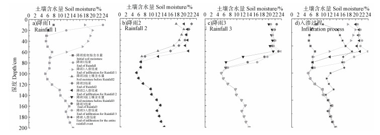
7月26日—7月28日共有3次集中降雨事件,总降雨量为158.30 mm。降雨事件分别发生在7月26日0:00~8:00(降雨1)、7月27日5:00~7:00(降雨2)、7月28日6:00~13:00(降雨3),降雨量分别为114.50 mm、14.00 mm、31.80 mm。降雨1(图 3a)开始之前经历了长达15 d的干旱,降雨1结束时0~10 cm、10~20 cm土层的蓄水量有大幅增长,分别由7.78 mm、6.06 mm增至23.27 mm(199.10%)和11.77 mm(94.22%);30~40 cm土层蓄水量变化微小。湿润锋在降雨1入渗结束后(约20 h)达到最大深度70 cm,0~70 cm蓄水增量为138.36 mm,土壤蓄水量的增加主要集中在0~40 cm土层。降雨2(图 3b)开始距降雨1结束约27 h,降雨2降雨强度为7.00 mm·h-1。叠加此次降雨后,土层蓄水的响应深度达到80 cm。降雨2结束时土层的蓄水增量为16.20 mm,较降雨1增加了6.85%。降雨2入渗过程结束时0~80 cm土层蓄水增量为26.05 mm。
|
图 3 “7·26”极端暴雨土壤剖面含水量动态 Fig. 3 Dynamics of soil water content in soil profile as affected by the"7·26"severe rainstorm |
降雨3(图 3c、图 3d)开始距降雨2结束约54 h,降雨强度为4.54 mm·h-1。叠加降雨1和降雨2后,降雨3结束时土壤蓄水的响应深度为90 cm,降雨3入渗过程结束时湿润锋达到最大深度100 cm,蓄水量较降雨1、降雨2分别增加了42.86%、25.01%。直到8月4日土壤水分再分配结束时,湿润锋达到最深深度为140 cm,土壤蓄水量达到225.99 mm,较降雨前95.37 mm增加了137%。
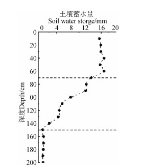
2.2 极端暴雨条件下土壤剖面蓄水量垂向分布特征根据不同层次土壤蓄水量与降雨过程响应的显著性差异[18],可将桥沟草地剖面土壤水分在垂直方向上划分为三个层次:土壤水分速变层(0~60 cm)、土壤水分活跃层(60~140 cm)和土壤水分稳定层(140~200 cm)。不同层次土壤蓄水量增减值变化范围分别为15.49~16.72 mm、2.01~13.27 mm和0.22~0.44 mm(图 4)。
|
图 4 土壤剖面蓄水量变化动态 Fig. 4 Dynamics of water storage in soil profile |
“7·26”极端暴雨条件下,桥沟草地土壤剖面降雨入渗所能达到的最大深度为140 cm。0~140 cm土层对降雨有较强的容蓄作用。降雨前0~140 cm土层平均蓄水量(6.81 mm)较降雨前140~200 cm稳定层平均蓄水量(12.48 mm)低约45.43%。降雨结束后,0~140 cm土层平均蓄水量(14.17 mm)为降雨前的2.08倍,稳定层平均蓄水量(12.20 mm)则较降雨前几乎无变化,且0~140 cm土层平均蓄水量较140~200 cm土层高约16.15%。0~60 cm和60~140 cm土层土壤蓄水量的平均值分别为17.37 mm(13.93~19.91 mm)和11.63 mm(9.21~16.53 mm),与降雨前各土层蓄水量相比均有显著增加,且增加量随土层深度的增加呈减少趋势。土壤水分与外界降雨交换的土层集中在0~140 cm土层,而140 cm以下土层的蓄水量则变化不明显。
2.3 极端暴雨条件下剖面土壤调蓄能力桥沟草地剖面0~140 cm土壤水分动态是影响该地区土壤水文过程的关键层次(图 5)。“7·26”极端暴雨条件下,桥沟草地土壤剖面降雨入渗所能达到的最大深度为140 cm;直到8月11日,重力水入渗深度均无法突破140 cm,进入更深层次。桥沟草地土壤剖面140 cm以下土层土壤水一直保持田间持水量状态。剖面0~140 cm土层,降雨前土壤含水量为6.67%,是田间持水量(13.24%)的50.38%;降雨结束后,土壤含水量超过田间持水量,达17.93%,约为田间持水量的1.35倍。剖面150~200 cm土层,降雨前土壤含水量为12.19%,与田间持水量(12.31%)相似;降雨结束后土壤含水量略有增加,为12.49%。可见,0~200 cm土壤具有较好的调蓄能力。

|
图 5 “7·26”极端暴雨前后土壤剖面含水量动态变化 Fig. 5 Dynamics of soil moisture during the"7·26"severe rainstorm event |
桥沟剖面土壤水分实时动态监测反映的与草被密切相关的土壤有效水层次为0~100 cm,100~140 cm为过渡层。草地剖面土壤降雨前经历了长达15d的持续干旱,0~100 cm土层草被的蒸腾作用(夏季7月)使得土壤剖面水分基本接近凋萎系数(图 5);100~140 cm剖面各层水分随深度增加逐渐接近田间持水量;140 cm土层以下保持田间持水量状态。
2.4 极端暴雨条件下土壤剖面水分入渗规律“7·26”暴雨主要集中在降雨1(26日0~8 h),且最强降雨出现在26日0~4 h,入渗过程体现了极端降雨条件下水分的入渗规律。按土壤水分受力情况及运动特征可分为三个阶段:渗润阶段、渗漏阶段和渗透阶段。渗润阶段,土壤含水量较低,入渗速度较大,随着水分不断入渗,土壤含水量增加,入渗速度迅速减小,这个阶段仅持续3 h左右;渗漏阶段,土壤含水量继续增加,下渗速度逐渐减小,这个阶段持续5 h左右;渗透阶段,土壤含水量达到田间持水量,下渗速度趋于稳定。霍顿方程能较好地模拟极端降雨条件下土壤水分入渗速率的变化过程(图 6a),利用霍顿方程将降雨1入渗速率随时间的变化趋势进行拟合分析,拟合曲线与降雨实测数据吻合程度较好,R2 =0.97,P < 0.01。降雨1累积入渗曲线呈逐渐增加后趋于稳定的趋势(图 6b),0~4 h内累积入渗量增幅较大。

|
图 6 “7·26”极端暴雨(降雨1)入渗过程曲线及累积入渗量曲线 Fig. 6 Infiltration process curve and cumulative infiltration curve during Rainfall 1 of the"7·26"severe rainstorm |
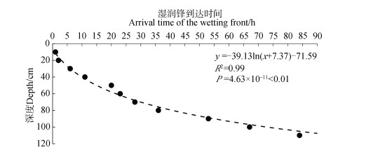
湿润锋的运动能够直观地反映水分入渗过程和渗流速度,将降雨过程中不同土层土壤水分含量开始增加的时间作为湿润锋到达的时间[19]。“7·26”极端暴雨过程中湿润锋的运动如图 7。降雨1开始后1h,湿润锋运动至10 cm处,11 h时则移动至40 cm深;23 h时湿润锋运动至6 cm土层,湿润锋的平均运动速度为2.63 cm·h-1;67 h时湿润锋到达100 cm土层,平均渗流速度为1.50 cm·h-1;100 cm以下深度的平均渗流速度为0.25 cm·h-1;226 h时湿润锋运动达到最大深度140 cm。
|
图 7 “7·26”极端暴雨湿润锋运动过程 Fig. 7 Wetting front movement process during the"7·26"severe rainstorm |
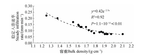
土壤容重与土壤稳定入渗速率关系如图 8所示。土壤容重与稳定入渗速率之间存在指数关系,稳定入渗速率随土壤容重的增加,呈指数函数递减。
|
图 8 土壤容重与稳定入渗速率的关系 Fig. 8 Relationship between soil bulk density and steady infiltration rate |
降雨入渗是土壤水文过程的关键环节之一,受气候因素(降雨强度、历时、降雨量)和下垫面因素(植被、土壤、地形地貌)等影响[20]。本研究发现,在极端降雨条件下,剖面土壤与外界降雨发生交互影响的土壤层次为0~140 cm;140 cm以下土层一直保持田间持水量状态,与土壤水分入渗和降雨再分配无明显关系。其中,0~60 cm土层含水量对降雨变化的响应最敏感;60~140 cm土层蓄水量存在明显的滞后现象。关于土壤水分垂向运动变化特征的研究表明[21],0~90 cm土层含水量对降雨入渗敏感,90~160 cm土层含水量则对降雨入渗迟缓,160~240 cm土层仅受重力水影响,与本研究中土壤水分对极端降雨的响应具有相似性。与一般降雨相比,极端暴雨的区别主要体现为降雨量及降雨强度大。而“7·26”极端降雨过程中,土壤含水量随降雨入渗而变化,并且含水量的变化与降雨量和降雨强度大小成正相关,如张敬晓等[21]、李毅和邵明安[22]、刘小璐等[23]发现,降雨强度越大,入渗率和累积入渗量均越大,对表层土壤水分的影响也越大,表明入渗过程受降雨性质的影响。地表产流与降雨-入渗过程密切相关,产流能力主要取决于降雨强度和土壤的入渗能力。李彬权等[24]、刘晓燕等[25]认为,入渗在一定程度上延缓了径流产生的时间,降低了径流量,但受暴雨的影响,产流机制表现为超渗产流。陈力等[26]模拟研究坡面降雨入渗产流规律得出了渗透率增大,产流过程所有参量均减小的结论。本研究认为,极端降雨过程中由于降雨强度远大于土壤入渗速率,且入渗量亦小于降雨量,其坡面产流机制仍以超渗产流为主,土壤的入渗性能在很大程度上影响产流机制。
极端暴雨条件下土壤水分入渗过程的动态监测对于研究土壤水文过程具有重要意义,能够反映出特定地区土壤的蓄水能力、持水能力和入渗能力[27]。黄土高原土壤的蓄水能力受到土壤性质的影响,其入渗深度一般较浅,降雨无法到达土壤深层,使得土壤蓄水能力在浅层和深层存在较大的差异[28]。桥沟草地0~140 cm土层对降雨有较强的容蓄作用,平均蓄水量较140~200 cm土层高约26.49%,蓄水量为降雨前的1.37倍,稳定层(140~200 cm)蓄水量较降雨前几乎无变化。土壤的蓄水能力反映土壤的结构和物理性质,在一定程度上影响着土壤的持水能力和入渗能力。已有研究表明,土壤容重和孔隙度[29]是影响土壤持水能力的重要因素,土壤饱和含水率与土壤保水和蓄水能力呈正比[30]。黄土高原植被恢复与重建使表层土壤物理性质发生了重要改变,表现为土壤容重减少、土壤孔隙数、孔隙度增加;土壤渗透系数和持水能力显著提高[31],如5年、20年、30年林草地土壤含水量分别为农地的1.41倍、1.44倍、1.72倍;土壤稳定渗透率分别为农地的1.78倍、2.84倍、3.44倍[32]。土壤结构和物理特性的变化势必对土壤的蓄水能力、持水能力和入渗能力产生重要影响。土壤的入渗性能直观反映于土壤入渗速率,亦受土壤物理性质的显著影响[31]。土壤入渗率受土壤容重影响较大,土壤入渗率随着容重的增大而递减[33-34],本研究结果也证实了这一点,“7·26”极端降雨过程中土壤入渗率随着容重的增大呈递减趋势。本研究反映了桥沟草地土壤在极端降雨条件下土壤水分入渗的特例,仅揭示了极端暴雨条件下的土壤水文参量的特征与规律。要阐明黄土高原降雨条件下土壤水分入渗过程的一般性规律,还需要更多降雨资料、监测点及更长监测时间做进一步的研究。
水文模型常常用来进行水文规律研究,并解决实际生产问题,在水文理论研究和实践中具有重要意义。入渗-产流过程是水文过程模拟的关键环节之一,自然降雨入渗和水文模型所用的积水入渗有很大差异,研究表明,自然降雨入渗受制于降雨强度变化,供水不足[35],如SWAT模型所使用的Green-Ampt入渗法是基于积水条件下建立的,在供水条件上与自然降雨条件下入渗有很大的区别,不能真实反映土壤入渗过程和径流形成过程。自然降雨条件下,雨强的变化促进水分向土层深处入渗,累积入渗量显著增加[36],极端降雨条件下,累积入渗量相应也越大。极端暴雨条件下土壤水文变化的实时监测有助于模型更准确模拟实际降雨入渗过程。降雨—入渗—产流过程亦是影响土壤侵蚀的重要环节之一,极端降雨事件的入渗过程可以反映极端降雨与产汇流之间的关系,有助于完善土壤侵蚀预报模型对土壤侵蚀的模拟。
4 结论基于桥沟草地土壤剖面水分动态监测,探讨了极端降雨条件下土壤水文参量和入渗过程特征与规律,主要结论如下:总体上,不同层次蓄水量与降雨过程的响应不同,土壤水分对降雨的响应时间随深度的增加呈现不同程度的滞后效应。桥沟草地土壤剖面水分的垂向运动具有层次性,分为土壤水分速变层(0~60 cm)、土壤水分活跃层(70~140 cm)和土壤水分稳定层(150~200 cm)。研究发现0~140 cm土层是影响该地区土壤水文过程的关键层次,其中与草被密切相关的土壤有效水层次为0~100 cm,100~140 cm为过渡层。霍顿方程能很好地模拟降雨的入渗过程(R2 =0.97,P < 0.01),入渗速率随时间呈指数关系。入渗过程中渗流速度遵循先快后慢的规律,湿润锋的运动趋势呈对数关系(P < 0.01)。降雨入渗特征参数受土壤物理性质影响,土壤稳渗速率与容重呈负相关,减幅随容重的增大而减缓。降雨入渗特征参数与持水能力取决于土壤结构和物理性质,入渗作用在一定程度上影响降雨-产流机制。
| [1] |
Devia G K, Ganasri B P, Dwarakish G S. A review on hydrological models . Aquatic Procedia, 2015, 4: 1001-1007. DOI:10.1016/j.aqpro.2015.02.126
(  0) 0) |
| [2] |
杨阳, 朱元骏, 安韶山. 黄土高原生态水文过程研究进展. 生态学报, 2018, 38(11): 4052-4063. Yang Y, Zhu Y J, An S S. Review on ecohydrological processes in Loess Plateau (In Chinese). Acta Ecologica Sinica, 2018, 38(11): 4052-4063. (  0) 0) |
| [3] |
Li S, Liang W, Fu B J, et al. Vegetation changes in recent large-scale ecological restoration projects and subsequent impact on water resources in China's Loess Plateau . Science of the Total Environment, 2016, 569/570: 1032-1039. DOI:10.1016/j.scitotenv.2016.06.141
(  0) 0) |
| [4] |
Zhao X N, Chen X L, Huang J, et al. Effects of vegetation cover of natural grassland on runoff and sediment yield in loess hilly region of China . Journal of the Science of Food and Agriculture, 2014, 94(3): 497-503.
(  0) 0) |
| [5] |
Ren Z P, Zhu L J, Wang B, et al. Soil hydraulic conductivity as affected by vegetation restoration age on the Loess Plateau, China . Journal of Arid Land, 2016, 8(4): 546-555. DOI:10.1007/s40333-016-0010-2
(  0) 0) |
| [6] |
Gasch C, Huzurbazar S, Stahl P. Measuring soil disturbance effects and assessing soil restoration success by examining distributions of soil properties . Applied Soil Ecology, 2014, 76: 102-111. DOI:10.1016/j.apsoil.2013.12.012
(  0) 0) |
| [7] |
李楠.下垫面变化条件下的黄土高原产汇流机制辨析研究.郑州: 郑州大学, 2018. Li N. Study on the mechanism of runoff production and confluence in the loess plateau under the change of underlying surface. Zhengzhou: Zhengzhou University, 2018. (  0) 0) |
| [8] |
张红艳, 张敬东, 时铁彬. 流域产流汇流问题的理论探讨. 农业与技术, 2013, 33(11): 49-50. Zhang H Y, Zhang J D, Shi T B. Theoretical discussion of the problem of runoff production and confluence in watershed (In Chinese). Agriculture and Technology, 2013, 33(11): 49-50. DOI:10.3969/j.issn.1671-962X.2013.11.037 (  0) 0) |
| [9] |
芮孝芳. 随机产汇流理论. 水利水电科技进展, 2016, 36(5): 8-12, 39. Rui X F. Random theory of runoff yield and flow concentration (In Chinese). Advances in Science and Technology of Water Resources, 2016, 36(5): 8-12, 39. (  0) 0) |
| [10] |
钟科元, 郑粉莉, 吴红艳, 等. 松花江流域极端降雨变化对流域输沙量的影响. 农业机械学报, 2017, 48(8): 245-252, 321. Zhong K Y, Zheng F L, Wu H Y, et al. Effects of precipitation extremes change on sediment load in Songhua River Basin (In Chinese). Transactions of the Chinese Society for Agricultural Machinery, 2017, 48(8): 245-252, 321. (  0) 0) |
| [11] |
李慧娟, 高建恩, 张元星, 等. 延安极端降雨特性分析及对梯田侵蚀灾害影响. 水土保持学报, 2016, 30(6): 79-84. Li H J, Gao J E, Zhang Y X, et al. Analysis of Yan'an extreme rainfall characteristics and impacts of erosion disasters on terraces (In Chinese). Journal of Soil and Water Conservation, 2016, 30(6): 79-84. (  0) 0) |
| [12] |
IPCC. Climate change2007: The physical science basis//contribution of working group I to the fourth assessment report of the intergovernmental panel on Climate Change. Cambridge: Cambridge University Press, 2007.
(  0) 0) |
| [13] |
王玲玲.黄土丘陵沟壑区不同空间尺度地貌单元水沙耦合机制.陕西杨凌: 西北农林科技大学, 2017. Wang L L. Runoff-sediment coupling mechanism of different geomorphic unit in the loess hilly-gully region. Yangling, Shaanxi: Northwest A & F University, 2017. (  0) 0) |
| [14] |
Topp G C, Davis J L, Annan A P. Electromagnetic determination of soil water content:Measurements in coaxial transmission lines . Water Resources Research, 1980, 16(3): 574-582.
(  0) 0) |
| [15] |
Reynolds S G. The gravimetric method of soil moisture determination Part I A study of equipment, and methodological problems . Journal of Hydrology, 1970, 11(3): 258-273.
(  0) 0) |
| [16] |
侯贵荣, 余新晓, 刘自强, 等. 不同降雨强度下北京山区典型林地土壤水分时空变化特征. 水土保持学报, 2017, 31(3): 209-215. Hou G R, Yu X X, Liu Z Q, et al. Spatial and temporal variation characteristics of soil moisture in typical forest land in Beijing mountain region under different rainfall intensity (In Chinese). Journal of Soil and Water Conservation, 2017, 31(3): 209-215. (  0) 0) |
| [17] |
肖庆礼, 黄明斌, 邵明安, 等. 黑河中游绿洲不同质地土壤水分的入渗与再分布. 农业工程学报, 2014, 30(2): 124-131. Xiao Q L, Huang M B, Shao M A, et al. Infiltration and drainage processes of different textural soil moisture in middle reaches of Heihe River Basin (In Chinese). Transactions of the Chinese Society of Agricultural Engineering, 2014, 30(2): 124-131. (  0) 0) |
| [18] |
韩仕峰, 李玉山, 张孝中, 等. 黄土高原地区土壤水分区域动态特征. 中国科学院水利部西北水土保持研究所集刊(黄土高原区域治理技术体系与效益评价专集), 1989(1): 161-167. Han S F, Li Y S, Zhang X Z, et al. The regional dynamic characteristics of soil water on the loess plateau (In Chinese). The Journal of Institute of Northwest Soil and Water Conservation of Ministry of Water Resources, Chinese Academy of Sciences(Special Collection of Technical Management System and Benefit Evaluation of the Loess Plateau), 1989(1): 161-167. (  0) 0) |
| [19] |
Rimon Y, Dahan O, Nativ R, et al. Water percolation through the deep vadose zone and groundwater recharge:Preliminary results based on a new vadose zone monitoring system . Water Resources Research, 2007, 43(5): 1-12.
(  0) 0) |
| [20] |
申红彬, 徐宗学, 张书函. 流域坡面汇流研究现状述评. 水科学进展, 2016, 27(3): 467-475. Shen H B, Xu Z X, Zhang S H. Review on the simulation of overland flow in hydrological models (In Chinese). Advances in Water Science, 2016, 27(3): 467-475. (  0) 0) |
| [21] |
张敬晓, 汪星, 汪有科, 等. 黄土丘陵区林地干化土壤降雨入渗及水分迁移规律. 水土保持学报, 2017, 31(3): 231-238. Zhang J X, Wang X, Wang Y K, et al. Regularities of rainfall infiltration and water migration in woodland drying soil in the Loess Hilly Region (In Chinese). Journal of Soil and Water Conservation, 2017, 31(3): 231-238. (  0) 0) |
| [22] |
李毅, 邵明安. 人工草地覆盖条件下降雨入渗影响因素的实验研究. 农业工程学报, 2007, 23(3): 18-23. Li Y, Shao M A. Experimental study on influence factors of rainfall and infiltration under artificial grassland coverage (In Chinese). Transactions of the Chinese Society of Agricultural Engineering, 2007, 23(3): 18-23. DOI:10.3321/j.issn:1002-6819.2007.03.004 (  0) 0) |
| [23] |
刘小璐, 鲁克新, 李鹏, 等. 不同降雨条件下坡面土壤水分入渗过程研究与模拟. 干旱区资源与环境, 2018, 32(11): 114-118. Liu X L, Lu K X, Li P, et al. Research and simulation of soil water infiltration on slope under different rainfall conditions (In Chinese). Journal of Arid Land Resources and Environment, 2018, 32(11): 114-118. (  0) 0) |
| [24] |
李彬权, 牛小茹, 梁忠民, 等. 黄河中游干旱半干旱区水文模型研究进展. 人民黄河, 2017, 39(3): 1-4, 9. Li B Q, Niu X R, Liang Z M, et al. Progress of research on hydrological models for arid and semi-arid areas of the Middle Yellow River (In Chinese). Yellow River, 2017, 39(3): 1-4, 9. DOI:10.3969/j.issn.1000-1379.2017.03.001 (  0) 0) |
| [25] |
刘晓燕, 刘昌明, 杨胜天, 等. 基于遥感的黄土高原林草植被变化对河川径流的影响分析. 地理学报, 2014, 69(11): 1595-1603. Liu X Y, Liu C M, Yang S T, et al. Influences of shrubs-herbs-arbor vegetation coverage on the runoff based on the remote sensing data in Loess Plateau (In Chinese). Acta Geographica Sinica, 2014, 69(11): 1595-1603. DOI:10.11821/dlxb201411001 (  0) 0) |
| [26] |
陈力, 刘青泉, 李家春. 坡面降雨入渗产流规律的数值模拟研究. 泥沙研究, 2001(4): 61-67. Chen L, Liu Q Q, Li J C. Study on the runoff generation process on the slope with numerical method (In Chinese). Journal of Sediment Research, 2001(4): 61-67. DOI:10.3321/j.issn:0468-155X.2001.04.012 (  0) 0) |
| [27] |
Chen H S, Shao M G, Li Y Y. The characteristics of soil water cycle and water balance on steep grassland under natural and simulated rainfall conditions in the Loess Plateau of China . Journal of Hydrology, 2008, 360(1/4): 242-251.
(  0) 0) |
| [28] |
陈强, Yuriy S Kravchenko, 陈渊, 等. 少免耕土壤结构与导水能力的季节变化及其水保效果. 土壤学报, 2014, 51(1): 11-21. Chen Q, Kravchenko Y S, Chen Y, et al. Seasonal variations of soil structures and hydraulic conductivities and their effects on soil and water conservation under no-tillage and reduced tillage (In Chinese). Acta Pedologica Sinica, 2014, 51(1): 11-21. (  0) 0) |
| [29] |
鞠忻倪, 贾玉华, 甘淼, 等. 黄土沟壑区不同地形部位土壤大孔隙特征研究. 土壤学报, 2018, 55(5): 1098-1107. Ju X N, Jia Y H, Gan M, et al. Characteristics of soil macropores in the gully area of loess plateau as affected by terrain (In Chinese). Acta Pedologica Sinica, 2018, 55(5): 1098-1107. (  0) 0) |
| [30] |
解文艳, 樊贵盛. 土壤含水量对土壤入渗能力的影响. 太原理工大学学报, 2004, 35(3): 272-275. Xie W Y, Fan G S. Influence of moisture content on infiltration characteristics in field soils (In Chinese). Journal of Taiyuan University of Technology, 2004, 35(3): 272-275. DOI:10.3969/j.issn.1007-9432.2004.03.008 (  0) 0) |
| [31] |
王长燕, 郁耀闯. 黄土丘陵区退耕草地土壤分离能力季节变化研究. 土壤学报, 2016, 53(4): 1047-1055. Wang C Y, Yu Y C. Seasonal variation of soil detachment in fields under "Grain for Green" in hilly regions of Loess Plateau of China (In Chinese). Acta Pedologica Sinica, 2016, 53(4): 1047-1055. (  0) 0) |
| [32] |
张笑培.黄土高原丘陵沟壑区植被恢复生态效应研究.陕西杨凌: 西北农林科技大学, 2008. Zhang X P. Research on the ecological effects of vegetation restoration in hilly and gully regions of Loess Plateau. Yangling, Shaanxi: Northwestern A & F university, 2008. (  0) 0) |
| [33] |
霍嘉仪, 陈丽华, 及金楠, 等. 晋西黄土区不同林地类型对土壤水分特性的影响. 山地学报, 2018, 36(3): 364-371. Huo J Y, Chen L H, Ji J N, et al. Effects of different types of woodland on soil moisture characteristics in the Loess Plateau of Western Shanxi Province, China (In Chinese). Mountain Research, 2018, 36(3): 364-371. (  0) 0) |
| [34] |
娄义宝, 史东梅, 蒋平, 等. 紫色丘陵区城镇化不同地貌单元的水文特征及土壤重构. 土壤学报, 2018, 55(3): 650-663. Lou Y B, Shi D M, Jiang P, et al. Hydrological characteristics and soil reconstruction of different landform units as affected by urbanization process in Purple Hilly Area (In Chinese). Acta Pedologica Sinica, 2018, 55(3): 650-663. (  0) 0) |
| [35] |
余新晓. 降雨入渗及产流问题的研究进展和评述. 北京林业大学学报, 1991(4): 88-94. Yu X X. Research progress and review on rainfall infiltration and runoff problems (In Chinese). Journal of Beijing Forestry University, 1991(4): 88-94. (  0) 0) |
| [36] |
张杰, 韩同春, 豆红强, 等. 探讨变雨强条件下的入渗过程及影响因素. 岩土力学, 2014, 35(S1): 451-456. Zhang J, Han T C, Dou H Q, et al. Study of infiltration process and its influential factors under variable rainfall intensity (In Chinese). Rock and Soil Mechanics, 2014, 35(S1): 451-456. (  0) 0) |
2. Institute of Soil and Water Conservation, Chinese Academy of Sciences and Ministry of Water Resources, Yangling, Shaanxi 712100, China;
3. College of Water Resources and Architectural Engineering, Northwest A & F University, Yangling, Shaanxi 712100, China;
4. Mountain Areas Research Institute of Hebei Province, Agricultural University of Hebei, Baoding, Hebei 071001, China
 2020, Vol. 57


