2. 中国科学院水利部水土保持研究所, 陕西杨凌 712100;
3. 沈阳农业大学水利学院, 沈阳 110866;
4. 中国科学院地理科学与资源研究所, 北京 100101;
5. 中国科学院大学资源与环境学院, 北京 100190
2. Institute of Soil and Water Conservation, Chinese Academy of Sciences, Yangling, Shaanxi 712100, China;
3. College of Water Conservancy, Shenyang Agricultural University, Shenyang 110866, China;
4. Institute of Geographic Sciences and Natural Resources Research, Chinese Academy of Sciences, Beijing 100101, China;
5. College of Resources and Environment, University of Chinese Academy of Sciences, Beijing 100190, China
土壤水作为水资源的重要组成部分,其在水资源的形成、转化以及消耗过程中发挥着重要作用;是维系土壤-植物-大气连续体(SPAC)的重要环节,与农业、水文和环境等学科联系密切[1-3]。黄土高原地形破碎,沟壑纵横,影响坡面水循环和流域水资源利用,且黄土高原降雨稀少,蒸散发强烈,土壤水分是黄土高原水蚀风蚀区植被建设的限制因子,土壤含水率的高低及分布特征在某种程度上决定了植被恢复的效益与布局[4]。
黄土高原土层深厚,地下水埋藏深[5],故浅层土壤受地下水补给困难,研究表明降水入渗深度多在距地表200 cm范围内,土壤水分常处于亏缺状态[6]。但深厚黄土层同样具有极强的储水能力,点棱接触和相互支架的多孔结构为水分贮存提供了良好的空间[7],200 cm深土层的储水量最大可达45~60 cm,可对区域降水进行年内年际调节,以满足植物生长耗水需求[8]。然而,黄土高原“土壤水库”[7]入不敷出,亏缺日趋严重,对年际或季节性干旱的调节能力降低,当年降水量成为植被生长的水分供体。
大规模植树造林虽然提高了黄土高原植被覆盖度[9],但也导致土壤水分亏缺[10],从而形成土壤干层[11]。干层是指因气候变化、地表植被过度消耗土壤储水量而导致的土壤干燥化土层[12-13],干层的存在会切断或减缓土壤水分上下层之间的交换,导致土壤环境恶化,植被退化[12-14]。考虑这一作用结果,许多学者针对干层作了一系列研究。结果表明干层广泛分布于黄土高原[15]。Wang等[16]研究分析了在整个黄土高原干层的厚度及起始深度,发现干层存在较强的空间变异,平均厚度为160 cm,平均起始深度为270 cm。董爽等[17]通过长期定位观测,指出黄土高原沟蚀区分水线干层问题较为严重,平均厚度介于40~800 cm。张晨成等[18]在六道沟流域一块13年杏树林地调查发现,侵蚀沟加剧了土壤水分蒸发,进而导致干层变厚。土壤干层已成为我国黄土高原开展生态文明建设,实现可持续发展面临的重大生态环境问题之一[12]。虽然已有研究加强了对干层的时空分布及影响因素的认识[12],但对切沟及其周边区域土壤水分分布及干层发育等问题尚研究不足。
根据2012年的调查结果,黄土高原地区长度超过500 m的侵蚀沟多达66万条[19],切沟作为黄土高原坡沟系统的重要组成部分,其发生发展和演变进程改变了坡面土壤水循环,流域水资源分布及利用效率,进而影响区域农业生产和生态恢复效益[12]。本研究以黄土高原六道沟流域典型切沟为主要研究对象,主要目的是分析对比沟底、沟缘、沟岸土壤水分时空分布及干层发育状况,探索切沟土壤储水量的影响因素。以期为该地区植被建造、水土保持、水资源合理利用提供科学依据。
1 材料与方法 1.1 研究区概况研究区位于陕西省神木市六道沟小流域(38°46′~38°51′ N,110°21′~110°23′ E),海拔高度为1 094~1 274 m。流域地处毛乌素沙漠边缘,流域面积为6.89 km2,主沟道接近南北走向,长约4.21 km,属于窟野河水系的二级支流[20]。主沟道两侧有多条支流,沟壑纵横地形破碎。该区位于黄土高原水蚀风蚀交错带的强烈侵蚀中心,多年平均降雨量为43 cm,年平均气温8.4 ℃[21],春季降雨稀少风力极大,以风力侵蚀为主,降雨集中在夏秋季节,水力侵蚀严重,自然环境十分恶劣[22]。流域土壤类型主要是由低肥力黄土发育而来的石灰性风化土。土壤黏聚力弱,渗透力强,保水率低,易受侵蚀。
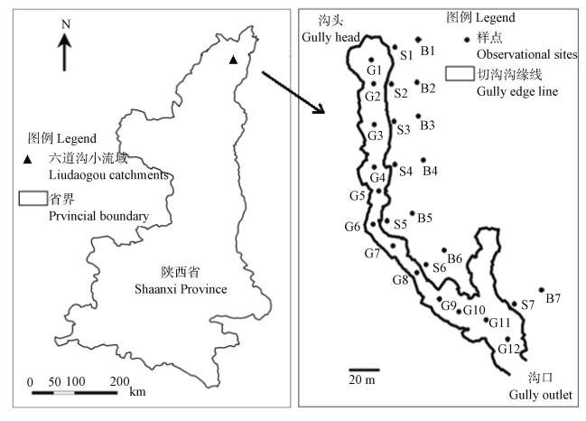
1.2 研究方法赵影等[23]对六道沟小流域内切沟进行了大量实地调查,测定了32条切沟的沟长和沟宽等形态特征,发现曲线型切沟最为常见;其中,沟长大于100 m的切沟占调查总数的81.2%,平均沟长为137.6 m。本研究综合考察了六道沟流域的地形、地貌和植被类型,在流域内选取一条典型切沟。该切沟沿沟道走向总长约为219 m,各断面沟宽3.5~22.2 m不等,下切深度最浅处为2.0 m,最深处达17.3 m。在切沟沟底纵向中心线、沟缘及距离沟缘20 m处布置三条样带,分别规定为沟底、沟缘和沟岸。切沟侧壁多为陡峭土壁,故沟缘样点实际距离沟缘线约1 m,试验期间切沟继续发育但侵蚀量并不明显,且切沟整体形态无明显变化。根据切沟走向,由沟头至沟口方向在沟底内依次布置12个样点,编号为G1~G12,在沟缘布置7个样点,编号为S1~S7,在沟岸布置7个样点,编号为B1~B7(图 1)。

|
注:G1~G12为沟底样点;S1~S7为沟缘样点;B1~B7为沟岸样点。Note:G1~G12:Sampling sites at the bottom of the gully;S1~S7:Sampling sites at the edge of the gully;and B1~B7:Sampling sites at the bank of the gully. 图 1 样点布置图 Fig. 1 Distribution of observational sites |
中子管布置采用土钻人工钻孔,钻孔后将铝质中子管竖直放置于孔内,将过筛后的干细土撒入铝管与土体间隙。因各样点基岩埋藏深度和钙质结核分布及厚度存在差异,故实际布设样点深度略有不同;其中,沟底样点深约480 cm,沟缘和沟岸大致为980 cm。钻孔同时,每隔20 cm深度采集扰动土样,用于分析土壤剖面颗粒组成。用体积为100 cm3的环刀采集0~30 cm土层原状土样,密封带回后立即称重,利用定水头法测定饱和导水率(Ks),土壤容重和总孔隙度的测定采用烘干法。在样点周围100 cm范围内放置50 cm × 50 cm样方框,先统计植物种类,然后收割样方框内贴近地表处植物地上部分,同时收集样方内枯落物。所有植物样本带回实验室,在65 ℃条件下烘48 h至恒重,以此作为生物量。收集试验期间降水降雨情况,用于分析土壤水分变化。
在对某一区域定点反复测量土壤水分状况时,土壤水分状况通常会比较稳定地维持在某一水平[24-25]。试验期从2014年10月至2016年6月,于2014年10月、12月,2015年3—10月,2016年3月、4月和6月分别测量土壤含水率,共计13次;取各次测定平均值来计算分析土壤剖面水分分布,可以代表普遍情况。利用CNC503DR型中子仪测定各监测点土壤含水率,中子仪详细资料可参考文献[26]。0~100 cm土壤剖面每隔10 cm测定一次,100 cm剖面以下土层每隔20 cm测定一次。中子仪测量值由以下回归关系转换为体积含水率:
| $ {{\rm{SWC}} = 73.300 \times X + 3.9565\left( {{R^2} = 0.8966, P < 0.001} \right)} $ | (1) |
| $ {{\rm{SWC}} = 60.093 \times X + 1.8995\left( {{R^2} = 0.7579, \;\;\;{\kern 1pt} P < 0.001} \right)} $ | (2) |
式中,SWC为土壤体积含水率,X为中子仪测量值与标准计数(660)的比值[26-27]。0~10 cm土层土壤体积含水率由式(1)计算,10 cm以下由式(2)计算。文中提及的土壤含水率均为土壤体积含水率。
李玉山[14]以土壤稳定持水量作为土壤干层湿度上限,其数值约为田间持水量的50%~80%。切沟区0~30 cm土壤田间持水量为21.2%,结合已有研究对土壤干层湿度上限加以确定[11,13-14,16-17],本文将10.8%作为土壤干层湿度上限,约为田间持水量的51%。因表层土壤受降雨及光热影响明显,土壤水分含量随时间变化较大,故本研究在分析干层时,仅考虑100 cm剖面以下土层。基于干层厚度、起始深度和干层内平均含水率三个指标对干层进行描述。
1.3 数据分析土壤储水量由土壤体积含水率分层计算得来。除0~15 cm和95~110 cm为15 cm外,0~110 cm土壤剖面每10 cm划分为一个土层,110 cm以下剖面每20 cm划分一个土层;利用相应土层内体积含水率测量值计算单个土层储水量,各土层储水量叠加即为总储水量。相关计算及数据整理在Excel 2016中完成。利用SPSS 16.0进行相关性分析及显著性检验,图像由ArcGIS 10.3及Origin 9.0处理生成。
2 结果 2.1 切沟土壤水分空间分布特征沟底土壤含水率由沟头至沟口呈现明显增加趋势;随深度增加,各样点间土壤含水率差异性加大(图 2a,图 2b,图 2c)。样点G2土壤含水率最小,为11.34%,最大值23.41%出现在样点G11处。样点G7含水率为14.35%,明显低于相邻样点(G6:15.17%,G8:17.44%)。各样点土壤含水率在垂直方向呈波浪式变化,沟口200 cm以下土层水分状况良好(图 2c)。沟缘(0~980 cm)和沟岸(0~960 cm)土壤含水率随深度变化相似,表现为先迅速增加,后波动变化,各样点土壤平均含水率分别为13.91%和14.67%(图 2f);沟口土壤含水率在480 cm以下均明显高于沟头(图 2d,图 2e)。其中,B1和B3样点480 cm剖面以下土层土壤平均含水率(9.82%和11.06%)低于上层(15.10%和13.43%),而B2样点上、下两层土壤含水率数值相近(11.82%和12.08%)。480 cm以下土壤水分状况相对较差,可能存在较大范围干层。切沟区沟底、沟缘和沟岸0~480 cm剖面平均土壤含水率分别为17.14%、13.50%和14.40%;沟底土壤含水率最大,沟缘最为干燥。表层0~10 cm土壤含水率整体较低,沟底、沟缘和沟岸分别为10.41%、7.73%和8.70%(图 2f)。

|
注:(f)反映土壤含水率均值,图中G、S和B分别代表沟底、沟缘和沟岸。Note:(f)shows average soil moisture content,G,S and B stands for the gully bottom,edge and bank,respectively. 图 2 沟底0~480 cm(a,b,c),沟缘0~980 cm(d),沟岸0~960 cm(e)土壤含水率分布图 Fig. 2 Distribution of soil water content at the gully bottom(0~480 cm)(a, b, c), gully edge(0~980 cm)(d), and gully bank (0~960 cm)(e) |
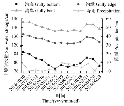
土壤水分是制约黄土高原植被恢复与重建的关键因子,降雨是该地区土壤水补充的唯一途径[15]。试验期间研究区累积降雨量为62.6 cm,但降雨分布不均,暴雨集中;如2015年6月29日单日降雨量达4.1 cm,占全年降雨量的10.3%。在2014年10月10日至2015年10月18日约一年时间内,切沟土壤储水量平均减少8.1 cm,占2014年10月10日测量值的6.7%,土壤水分条件恶化。2014年10月10日至2015年6月25日期间降雨量仅为4.8 cm,土壤储水量持续降低(图 3)。2015年7—9月,土壤储水量波动变化。同2015年3月和4月土壤储水量(117.7 cm和116.7 cm)相比,2016年相应月份(118.6 cm和118.0 cm)土壤储水量均有所增加。

|
注:图中2014.10.10降水为2014年9月累积降雨量,其余为监测期间隔累积降雨量。Note:The value of October 10,2014 in the figure is the cumulative rainfall in September 2014,and the others are the cumulative rainfall of their respective monitoring period. 图 3 观测期间沟底、沟缘和沟岸储水量随时间变化 Fig. 3 Soil water storage changes at the bottom, edge and bank of the gully relative to time during the observation period |
切沟沟底、沟缘和沟岸深层土壤储水量普遍高于浅层。沟底样点G12处,400~480 cm剖面土壤储水量为27.9 cm,约为0~100 cm土层(15.9 cm)的1.75倍;样点G12总储水量(111.9 cm)为G1(64.5 cm)的1.74倍。沟底土壤水分沿切沟纵向分布不均,沟口土壤储水量显著大于沟头(P < 0.01),然而沟缘土壤储水量沿沟道走向并未呈现明显规律。沟岸处土壤储水量亦表现为沟口大于沟头,其中样点B7总储水量为149.7 cm,显著低于(P < 0.05)B6样点(175.4 cm),上述差异可能是由样点B6和B7间的小冲沟破坏水分分布连续性所致。
研究区土壤储水量受距离沟头距离以及土壤质地显著影响(表 1)。其中,土壤储水量与距沟头距离、黏粒和粉粒含量呈极显著正相关,与砂粒含量呈极显著负相关。同时,黏粒和粉粒含量均与距沟头距离呈极显著正相关关系,砂粒含量与其呈极显著负相关。Biswas和Si[28]亦证实土壤储水量受地形、土壤质地、植被、水分运移过程以及地下水位等因素控制。总孔隙度与土壤饱和导水率呈极显著正相关,与土壤容重呈极显著负相关;较高的土壤容重意味着土壤颗粒间越紧密,孔隙越少,土壤导水能力降低[29]。
|
|
表 1 土壤储水量及其影响因素的Pearson相关性 Table 1 Pearson correlation analysis of soil water storage and it's influencing factors |
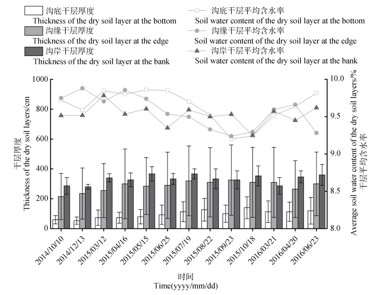
切沟干层厚度、起始深度及平均含水率见表 2,沟底、沟缘和沟岸均有干层形成,且集中出现在靠近沟头位置。沟底、沟缘和沟岸干层厚度依次为22~158 cm、58~532 cm和271~363 cm,平均厚度分别为100 cm、286 cm和331 cm;最小干层厚度出现在沟底,沟缘干层厚度变化范围最广。沟岸干层厚度相对均匀,呈现距沟头越近,干层越厚的趋势。沟底、沟缘和沟岸干层平均起始深度分别为178 cm、233 cm和368 cm。综合来看,沟缘线样点土壤干层起始深度变异较大,而沟岸样点土壤干层起始深度相对较深。沟底、沟缘和沟岸干层平均含水率分别为9.7%、9.4%和9.6%,切沟区干层平均含水率仅为9.5%,为土壤稳定持水量(10.8%)的88%。图 4显示三条样带干层平均厚度随时间均有变厚趋势(R2=0.45),干层呈现为继续发育状态。
|
|
表 2 干层分布特征 Table 2 Distribution characteristics of the dry soil layers |

|
图 4 观测期间沟底、沟缘和沟岸干层平均厚度及干层平均含水率变化 Fig. 4 Thickness(mean)and soil water content(mean)of the dry soil layers changes at the bottom, edge and bank of the gully relative to time during the observation period |
通常情况下,土壤含水率随土层深度的增加而增大[30]。研究区沟缘和沟岸土壤含水率随深度变化相似,表现为迅速增加,后波动变化;而沟底同沟缘和沟岸差异显著(P < 0.01),随深度增加,土壤含水率增加趋势更为明显。本研究所选切沟沟道为窄深形,沟底地势偏低形成相对稳定的小气候,空气湿度大且风速偏小,蒸散作用小于沟岸地,加之该地区降雨集中且多为暴雨,超渗产流的雨水既在坡长方向上形成径流,也沿沟岸地汇入沟道,使得沟底土壤含水率较高。王云强等[31]对黄土高原0~500 cm层次土壤含水率分析,发现各层土壤含水率在垂直方向变化平缓,呈现波浪式变化,最小值出现在60~90 cm土层。陕北风力较大且空气湿度低,表层土壤受气象条件影响突出,蒸散发严重,故本研究中土壤表层含水率普遍偏低。沟缘0~120 cm土层土壤含水率显著小于沟岸(P < 0.05),120 cm剖面以下,沟缘与沟岸土壤含水率均呈现波动变化,趋势相似且数值大小相近。这一现象主要是侧向蒸发造成的,沟缘距切沟较近,土壤水分受到正面和侧面双向蒸发影响,而在距沟道稍远的沟岸上可能只受正面蒸发,从而导致0~120 cm土层土壤含水率较沟缘要大。随土层深度的增加,沟缘土壤含水率波动变化幅度较沟岸大,侧壁蒸发仍存在一定影响。甘淼等[32]研究认为切沟的存在是沟缘表层土壤水分损失的重要原因。沟缘土壤水分为双侧蒸发[33],沟道走向的改变使得沟缘侧壁接受光照不同,进而引起土壤水分蒸发差异,造成沟缘土壤水分分布更加复杂。
贾小旭等[34]研究发现黄土高原0~500 cm剖面平均土壤储水量为73.5 cm,干燥度、黏粒、归一化植被指数和坡度是影响区域土壤蓄水量的主要因素。本研究中,沟底0~480 cm土层土壤平均储水量为80.54 cm,沟缘及沟岸分别为67.49 cm和71.05 cm,沟底土壤储水量显著大于沟缘、沟岸,且较黄土高原平均储水量[34]要大,沟缘储水量最小但与沟岸无明显差异,沟缘、沟岸储水量均小于黄土高原平均储水量。降雨是黄土高原地区土壤水补充的唯一来源。王乘书等[35]在降雨水分再分配结束后发现黄土丘陵沟壑区土壤储水量增加近1.37倍;姜娜等[36]在六道沟小流域天然降雨条件下,观测到不同土地利用方式下的土壤储水量变化与降雨量变化趋于一致,由此可见切沟区土壤储水量亦与降雨关系密切。试验期间(21个月)研究区累计降雨量为62.6 cm,低于多年平均降雨量,导致切沟土壤水分未能得到有效补充。切沟区土壤储水量受地形和土壤颗粒分布的显著影响。切沟复杂地形对降雨进行再分配,加之不同的保水能力,加大了切沟区土壤分布空间异质性。降雨事件发生时,径流由沟缘进入沟道,而后进一步向沟口汇集,沟口处水分入渗时间更长[37],加之土壤水在重力作用下向地势较低处运动,沟口处水分状况较好,对降雨的再分配增加了切沟区土壤水分空间异质性。此外,土壤水分分布还受土壤颗粒分布影响[32],研究区土壤颗粒分布与切沟发育过程密切相关(表 1)。沟头受到强烈的风蚀水蚀影响,存在强烈的溯源侵蚀;当发生降雨时,粉粒和黏粒更易被水流携带,细小土壤颗粒会在水分入渗作用下由土壤孔隙进入深层土壤,同时随水流向沟口运移[32]。贾小旭等[34]指出黏粒是影响区域土壤储水量的主要因素之一。当土壤中黏粒和粉粒含量较多时,土壤具有较大的比表面积,有更强的保水性;而当砂粒含量较多时,土壤空隙间连接性好,容易造成土壤水分蒸发以及渗漏流失[38],沟头处保水能力较沟口要差。
切沟区土壤干层空间分布异质性较强,沟头深层土壤水分状况相对较差,干层多在此处发育。整个黄土高原干层平均厚度为160 cm,起始深度平均为270 cm[16]。相比之下,切沟区干层平均厚度较大,达243 cm;起始深度相近,为257 cm。Wang等[13]在黄土高原林地125个研究点中发现有102个点出现干层,且干层厚度一般在300 cm以上;张晨成等[18]发现25年生杏树林干层厚度明显大于13年杏树林,并认为干层发育受植被、降水入渗、坡位和微地形等多种因素共同作用,认为植被是主要控制因素。本研究中,切沟区植被相对较少且无高大乔木,主要生长着胡枝子、紫花苜蓿和沙打旺等植物,其吸水能力通常较林地小。一般而言,草本植物主要利用0~300 cm土层的土壤水分[11],但不同植被根系对土壤水分的利用深度各异,加之切沟区域地形复杂,继而导致研究区干层发育与分布情况不同。沟缘和沟岸样点土壤干层起始深度范围为100~553 cm,广于沟蚀区分水线的研究结果[17](100~460 cm)。沟缘各样点土壤干层空间分布异质性最为突出。实地测量结果显示,样点S1处沟道下切深度较浅,约为2 m,而样点S2和S3处下切深度大于10 m;在土壤侧壁蒸发以及植被耗水共同作用下,样点S2和S3土壤水分损失多于S1,从而导致样点S1处干层厚度显著小于S2和S3。董爽等[17]于沟蚀区分水线发现干层起始深度越小,干层厚度越大;而本研究相关分析结果显示干层厚度与起始深度无显著相关关系(R2=0.05)。切沟地形较分水线更加复杂,水分分布及干层发育也存在差异。试验期间切沟区干层呈持续发育状态,复杂的干层形成过程是降雨补给困难,植被类型及其生长状况综合作用的结果;同时切沟侧壁加剧土壤水分蒸发的作用也不容忽视。
4 结论切沟及其周边区域范围内,沟底土壤水分状况优于沟缘和沟岸,沟缘水分亏缺最为明显且不同样点间土壤水分状况差异较大。0~480 cm土层,沿沟道向沟缘至坡面土壤储水量呈现先减小后增大的分布规律,且沟底土壤储水量显著大于沟缘及沟岸。沟口土壤水分状况好于沟头,深层普遍优于浅层。土壤水分及颗粒分布均受地形较大影响。切沟土壤储水量与距沟头距离、黏粒和粉粒含量呈极显著正相关;黏粒和粉粒含量与距沟头距离呈现极显著正相关关系,砂粒含量与距沟头距离呈极显著负相关。切沟干层主要发生在沟头位置,平均厚度为243 cm,起始深度为257 cm,较黄土高原干层平均厚度要深,干层问题严峻,干层平均含水率为9.5%,土壤干层长期稳定存在,若遇极端干旱天气,该区域土壤干层极有可能继续发育。
| [1] |
Hu W, Shao M A, Wang Q J, et al. Time stability of soil water storage measured by neutron probe and the effects of calibration procedures in a small watershed[J]. Catena, 2009, 79(1): 72-82. DOI:10.1016/j.catena.2009.05.012
(  0) 0) |
| [2] |
Gao X D, Wu P T, Zhang B Q, et al. Spatial variability of available soil moisture and its seasonality in a small watershed in the hilly region of the Loess Plateau (In Chinese)[J]. Acta Pedologica Sinica, 2015, 52(1): 57-67. [高晓东, 吴普特, 张宝庆, 等. 黄土丘陵区小流域土壤有效水空间变异及其季节性特征[J]. 土壤学报, 2015, 52(1): 57-67.]
(  0) 0) |
| [3] |
Yang Z H, Hu F N, Liu J F, et al. Water infiltration in soils developed from loess affected by surface electric field and simulation (In Chinese)[J]. Acta Pedologica Sinica, 2019, 56(6): 1359-1369. [杨志花, 胡斐南, 刘婧芳, 等. 土壤表面电场对黄土母质发育土壤水分入渗特性的影响及模拟[J]. 土壤学报, 2019, 56(6): 1359-1369.]
(  0) 0) |
| [4] |
Lin S, Wang Y R. Spatial-temporal evolution of precipitation in China Loess Plateau (In Chinese)[J]. Journal of Desert Research, 2007, 27(3): 502-508. DOI:10.3321/j.issn:1000-694X.2007.03.027 [林纾, 王毅荣. 中国黄土高原地区降水时空演变[J]. 中国沙漠, 2007, 27(3): 502-508.]
(  0) 0) |
| [5] |
Yang W Z, Shao M A. The research of the Loess Plateau soil moisture (In Chinese). Beijing: Science Press, 2000. [杨文治, 邵明安. 黄土高原土壤水分研究[M]. 北京: 科学出版社, 2000.]
(  0) 0) |
| [6] |
Yi C Q, Wang S, Fan J. Soil water dynamics of degraded grassland on the slope of the Loess Plateau (In Chinese)[J]. Acta Agrestia Sinica, 2015, 23(6): 1182-1189. [易彩琼, 王胜, 樊军. 黄土高原坡地退耕恢复草地的土壤水分动态[J]. 草地学报, 2015, 23(6): 1182-1189.]
(  0) 0) |
| [7] |
Zhu X M. Environment in Loess Plateau and "pedogenic reservoir (In Chinese)[J]. Quaternary Sciences, 2000, 20(6): 514-520. DOI:10.3321/j.issn:1001-7410.2000.06.003 [朱显谟. 试论黄土高原的生态环境与"土壤水库"——重塑黄土地的理论依据[J]. 第四纪研究, 2000, 20(6): 514-520.]
(  0) 0) |
| [8] |
王健.陕北黄土高原土壤水库动态特征的评价与模拟[D].陕西杨凌: 西北农林科技大学, 2008. Wang J. Evaluation and simulation of soil reservoir dynamic property in Loess Plateau in northern Shaanxi Province[D]. Yangling, Shaanxi: Northwest A & F University, 2008. (  0) 0) |
| [9] |
Zhou H J, van Rompaey A, Wang J A. Detecting the impact of the "Grain for Green" program on the mean annual vegetation cover in the Shaanxi Province, China using SPOT-VGT NDVI data[J]. Land Use Policy, 2009, 26(4): 954-960. DOI:10.1016/j.landusepol.2008.11.006
(  0) 0) |
| [10] |
Chen Y P, Wang K B, Lin Y S, et al. Balancing green and grain trade[J]. Nature Geoscience, 2015, 8(10): 739-741. DOI:10.1038/ngeo2544
(  0) 0) |
| [11] |
Wang Y Q, Shao M A, Shao H B. A preliminary investigation of the dynamic characteristics of dried soil layers on the Loess Plateau of China[J]. Journal of Hydrology, 2010, 381(1/2): 9-17.
(  0) 0) |
| [12] |
Shao M A, Jia X X, Wang Y Q, et al. A review of studies on dried soil layers in the Loess Plateau (In Chinese)[J]. Advances in Earth Science, 2016, 31(1): 14-22. [邵明安, 贾小旭, 王云强, 等. 黄土高原土壤干层研究进展与展望[J]. 地球科学进展, 2016, 31(1): 14-22.]
(  0) 0) |
| [13] |
Wang Y Q, Shao M A, Liu Z P, et al. Investigation of factors controlling the regional-scale distribution of dried soil layers under forestland on the Loess Plateau, China[J]. Surveys in Geophysics, 2012, 33(2): 311-330. DOI:10.1007/s10712-011-9154-y
(  0) 0) |
| [14] |
Li Y S. The properties of water cycle in soil and their effect on water cycle for land in the loess region (In Chinese)[J]. Acta Ecologica Sinica, 1983, 3(2): 91-101. [李玉山. 黄土区土壤水分循环特征及其对陆地水分循环的影响[J]. 生态学报, 1983, 3(2): 91-101.]
(  0) 0) |
| [15] |
Wang L, Shao M A, Zhang Q F. Distribution and characters of soil dry layer in north Shaanxi Loess Plateau (In Chinese)[J]. Chinese Journal of Applied Ecology, 2004, 15(3): 436-442. DOI:10.3321/j.issn:1001-9332.2004.03.016 [王力, 邵明安, 张青峰. 陕北黄土高原土壤干层的分布和分异特征[J]. 应用生态学报, 2004, 15(3): 436-442.]
(  0) 0) |
| [16] |
Wang Y Q, Shao M A, Liu Z P. Large-scale spatial variability of dried soil layers and related factors across the entire Loess Plateau of China[J]. Geoderma, 2010, 159(1/2): 99-108.
(  0) 0) |
| [17] |
Dong S, Li T C, Guo C J, et al. Distribution of dried soil layers on the dividing waterline in the gully area of the Loess Plateau (In Chinese)[J]. Advances in Water Science, 2017, 28(6): 811-819. [董爽, 李同川, 郭成久, 等. 陕北黄土区流域分水线土壤干层分布[J]. 水科学进展, 2017, 28(6): 811-819.]
(  0) 0) |
| [18] |
Zhang C C, Shao M A, Wang Y Q. Spatial distribution of dried soil layers under different vegetation types at a slope scale in loess region (In Chinese)[J]. Transactions of the CSAE, 2012, 28(17): 102-108. DOI:10.3969/j.issn.1002-6819.2012.17.015 [张晨成, 邵明安, 王云强. 黄土区坡面尺度不同植被类型下土壤干层的空间分布[J]. 农业工程学报, 2012, 28(17): 102-108.]
(  0) 0) |
| [19] |
Zheng F L, Wang B. Soil erosion in the Loess Plateau region of China . Tokyo: Springer Japan, 2013: 77-92.
(  0) 0) |
| [20] |
李同川.黄土高原土壤大孔隙特征及其对土壤水分的影响[D].陕西杨凌: 西北农林科技大学, 2017. Li T C. Characteristics of soil macropore on the Loess Plateau and their effects on soil water[D]. Yangling, Shaanxi: Northwest A & F University, 2017. (  0) 0) |
| [21] |
Li T C, Shao M A, Jia Y H. Effects of activities of ants(Camponotus japonicus)on soil moisture cannot be neglected in the northern Loess Plateau[J]. Agriculture, Ecosystems & Environment, 2017, 239: 182-187.
(  0) 0) |
| [22] |
Tang K L, Hou Q C, Wang B K, et al. The environment background and administration way of wind-water erosion crisscross region and Shenmu experimental area on the Loess Plateau (In Chinese)[J]. Research of Soil and Water Conservation, 1993(2): 2-15. [唐克丽, 侯庆春, 王斌科, 等. 黄土高原水蚀风蚀交错带和神木试区的环境背景及整治方向[J]. 水土保持研究, 1993(2): 2-15.]
(  0) 0) |
| [23] |
Zhao Y, Dong S, Jia Y H. Morphological complex and classification of gullies in the Liudaogou minor drainage basin in north Shaanxi Province (In Chinese)[J]. Arid Zone Research, 2019, 36(5): 1292-1299. [赵影, 董爽, 贾玉华. 陕北六道沟流域切沟形态复杂性及其类型划分[J]. 干旱区研究, 2019, 36(5): 1292-1299.]
(  0) 0) |
| [24] |
Pachepsky Y A, Guber A K, Jacques D. Temporal persistence in vertical distributions of soil moisture contents[J]. Soil Science Society of America Journal, 2005, 69(2): 347-352. DOI:10.2136/sssaj2005.0347
(  0) 0) |
| [25] |
Jia Y H, Shao M A, Jia X X. Spatial pattern of soil moisture and its temporal stability within profiles on a loessial slope in northwestern China[J]. Journal of Hydrology, 2013, 495: 150-161. DOI:10.1016/j.jhydrol.2013.05.001
(  0) 0) |
| [26] |
Huo Z, Shao M A, Horton R. Impact of gully on soil moisture of shrubland in wind-water erosion crisscross region of the Loess Plateau[J]. Pedosphere, 2008, 18(5): 674-680. DOI:10.1016/S1002-0160(08)60062-4
(  0) 0) |
| [27] |
Li T C, Shao M A, Jia Y H, et al. Profile distribution of soil moisture in the gully on the northern Loess Plateau, China[J]. Catena, 2018, 171: 460-468. DOI:10.1016/j.catena.2018.07.027
(  0) 0) |
| [28] |
Biswas A, Si B C. Revealing the controls of soil water storage at different scales in a hummocky landscape[J]. Soil Science Society of America Journal, 2011, 75(4): 1295-1306. DOI:10.2136/sssaj2010.0131
(  0) 0) |
| [29] |
Papanicolaou A T N, Elhakeem M, Wilson C G, et al. Spatial variability of saturated hydraulic conductivity at the hillslope scale:Understanding the role of land management and erosional effect[J]. Geoderma, 2015, 243/244: 58-68. DOI:10.1016/j.geoderma.2014.12.010
(  0) 0) |
| [30] |
Qiu Y, Fu B J, Wang J, et al. Spatial variability of soil moisture content and its relation to environmental indices in a semi-arid gully catchment of the Loess Plateau, China[J]. Journal of Arid Environments, 2001, 49(4): 723-750. DOI:10.1006/jare.2001.0828
(  0) 0) |
| [31] |
Wang Y Q, Shao M A, Liu Z P. Spatial variability of soil moisture at a regional scale in the Loess Plateau (In Chinese)[J]. Advances in Water Science, 2012, 23(3): 310-316. [王云强, 邵明安, 刘志鹏. 黄土高原区域尺度土壤水分空间变异性[J]. 水科学进展, 2012, 23(3): 310-316.]
(  0) 0) |
| [32] |
Gan M, Jia Y H, Li T C, et al. Variation of soil bulk density, saturated hydraulic conductivity and soil moisture content in a slope-gully unit on the northern loess plateau (In Chinese)[J]. Arid Zone Research, 2018, 35(2): 315-324. [甘淼, 贾玉华, 李同川, 等. 黄土区坡沟系统容重、饱和导水率和土壤含水量变化分析[J]. 干旱区研究, 2018, 35(2): 315-324.]
(  0) 0) |
| [33] |
Zheng J Y, Li Y Y, Shao M A, et al. Relationship between side evaporation of gully cliff and environment aridization in Loess Plateau (In Chinese)[J]. Science of Soil and Water Conservation, 2006, 4(3): 6-10. [郑纪勇, 李裕元, 邵明安, 等. 沟壁侧面蒸发与黄土高原环境旱化关系初探[J]. 中国水土保持科学, 2006, 4(3): 6-10.]
(  0) 0) |
| [34] |
Jia X X, Shao M A, Zhang C C, et al. Variation and simulation of soil water content within different soil depths along the south-north transect of the Loess Plateau (In Chinese)[J]. Advances in Water Science, 2016, 27(4): 520-528. [贾小旭, 邵明安, 张晨成, 等. 黄土高原南北样带不同土层土壤水分变异与模拟[J]. 水科学进展, 2016, 27(4): 520-528.]
(  0) 0) |
| [35] |
Wang C S, Yang X N, Sun W Y, et al. Soil water storage capacity and rainwater infiltration in hilly-gully loess region under severe rainstorm (In Chinese)[J]. Acta Pedologica Sinica, 2020, 57(2): 296-306. [王乘书, 杨晓楠, 孙文义, 等. 极端暴雨条件下黄土丘陵沟壑区土壤蓄水能力和入渗规律[J]. 土壤学报, 2020, 57(2): 296-306.]
(  0) 0) |
| [36] |
Jiang N, Shao M A, Lei T W, et al. Soil water characteristics of different typical land use patterns in water-wind erosion interlaced region (In Chinese)[J]. Journal of Beijing Forestry University, 2007, 29(6): 134-137. [姜娜, 邵明安, 雷廷武, 等. 水蚀风蚀交错带典型土地利用方式土壤水分变化特征[J]. 北京林业大学学报, 2007, 29(6): 134-137.]
(  0) 0) |
| [37] |
Melliger J J, Niemann J D. Effects of gullies on space–time patterns of soil moisture in a semiarid grassland[J]. Journal of Hydrology, 2010, 389(3/4): 289-300.
(  0) 0) |
| [38] |
Zeleke T B, Si B C. Scaling relationships between saturated hydraulic conductivity and soil physical properties[J]. Soil Science Society of America Journal, 2005, 69(6): 1691-1702.
(  0) 0) |
 2021, Vol. 58


